Proposed NSW Government changes in coastal management signalled its intention to allow individual landowners the right to apply to protect their properties from erosion. But these proposed changes fail to address the medium-term (~40 years) problem, whilst promoting ad hoc coastal protection measures.
Medium-term engineering solutions, including beach nourishment to defend some residential areas, should not be ruled out. Parts of the present coastline may well need to be abandoned as they become impractical and too expensive to protect, but this time has not yet arrived.
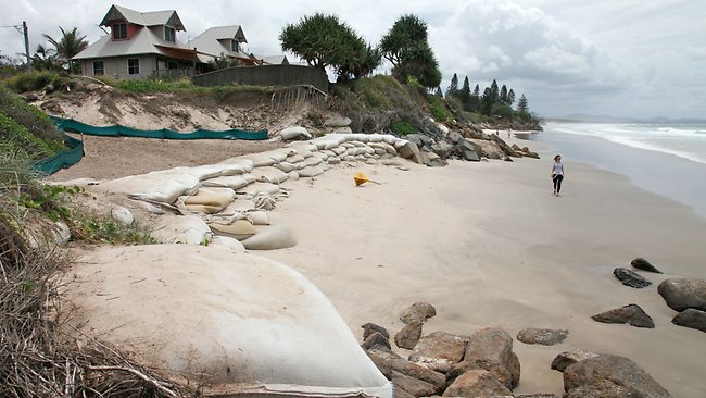
Rising sea levels and increased coastal populations will place continuing pressure on beaches, and an integrated approach to managing the coastal zone is called for. Byron Bay was classified as a beach ‘erosion hotspot’ by the Australian Government in 2009.
Byron Bay Background
Coastal erosion impacts on infrastructure are no stranger to the Bay. In 1928 a new jetty was built to replace the original (built in 1888), which had been damaged by heavy seas. The rebuilt jetty was in turn damaged in 1948 and its replacement mostly lost in 1954 in heavy seas generated by Tropical Cyclone (TC) 137 (Roche et al. 2012). With continued growth, the town struggles to balance development and natural preservation, and the debate over coastal management has polarised the community.
Under the previous NSW Labor government (1995–2011), coastal legislation was focused on the long term. The ‘precautionary’ principle of planned retreat was invoked to deal with sea-level rise anticipated as a consequence of global climate change. Medium-term solutions — engineering solutions — were ignored. Whilst the latest policy developments under the new Liberal government (elected in 2011) still lack detail, planned retreat has been revoked and the door opened for landowners to be given the right to protect their properties in the short term.
By way of background, we begin with a brief summary of relevant science. This is followed by the chronology of the development of the Coastal Protection Act (CPA), before examining some aspects of the Byron Bay legal case that helped trigger changes to the legislation. We then consider the most recent changes proposed by the new Liberal government. We conclude by revisiting science and engineering-based solutions.
The attribution of the recessional shoreline trend at Belongil Beach has not been fully determined. However, four processes contribute to the problem. Three of these are:
- a decadal-scale sand-supply deficit in the longshore sand-transport rate bypassing Cape Byron and which is associated with fluctuations in wave climate (Goodwin, Freeman and Blackmore 2013)
- an increase in incident easterly storm-wave power; and
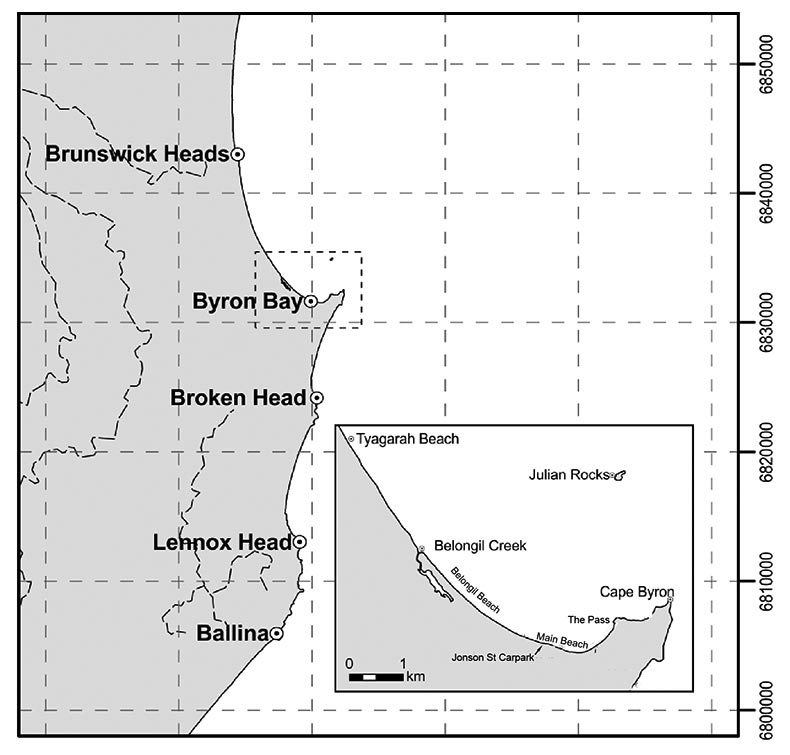
- the interruption of natural sand transport alongshore by the Jonson Street carpark (Byron Bay Central Business District (CBD) — see Figure 1).
A fourth potential mechanism is sea-level rise. Sea level has risen by ~0.075 m over the period since 1960, and is now rising at ~3 mm/yr on the NSW north coast. This coast also experiences inter-annual sea-level variations of +/- 0.25m associated with the La Niña/El Niño phenomenon.
Previous research has shown that it is unlikely that sea-level rise will have a detectable impact on shoreline position until at least 2050, and until this time sand supply fluctuations , combined with any anthropogenic engineering impacts, will continue to dominate the processes at Byron Bay. In the long term (post-2100), a monotonic or accelerating sea-level rise becomes an increasingly significant driver of shoreline change.
The Long Term: Planned Retreat
In 1974, Tropical Cyclone Pam caused large-scale beach erosion and after a succession of East Coast lows, the village of Sheltering Palms was abandoned, with 17 houses purchased under the Government’s Coastal Lands Protection Scheme. During this period the old beachfront track and several houses at Belongil Spit were lost. Initially in the 1970s, seawalls were constructed mostly by residents with Council assistance on an ad hoc basis, using car wrecks and other landfill. Following the 1974 cyclone, protective rock seawalls were constructed and coordinated by the Byron Shire Erosion Trust in 1975. At the same time, local industry used sea walls to protect the town’s main employer, F. J. Walker Meatworks, at Belongil Beach.
After the succession of storms in the 1970s, the State Government of NSW instigated a study into the erosion trends and coastal processes affecting the Byron Shire. The Byron Bay to Hastings Point Erosion Study concluded that the coastline was undergoing long-term recession. The Coastline Hazard Definition Study (WBM Oceanics Australia 2005) also noted a trend, although less marked, towards long-term recession, highlighting the ongoing loss of sand offshore at Cape Byron and citing the Jonson Street carpark/Memorial Pool protection works as the significant cause.
There are five management options for dealing with existing and future development on lands at risk to coastal erosion:
- no coordinated plan,
- re-zoning of affected areas,
- relocation,
- an insurance scheme, and
- engineering works.
In 1988, planning instruments for coastal precincts were adopted by the Byron Shire Council (BSC) following the Draft Development Control Plan (DCP) and a public hearing. They were heavily influenced by the Department of Public Works (PWD) Study (1978) with The Byron Local Environment Plan 1988 (Byron Shire Council 1988a) and DCP 1 (Byron Shire Council 1988b), stating that development on coastal lands needed to be either relocatable or protected by large engineering structures. As a result, approval of any new development, proposed additions or alterations to existing developments located in coastal planning precincts was conditional on the possibility of relocation or removal, should the erosion escarpment encroach within a certain distance as specified on the development consent. This has become known as the council’s planned retreat policy.
Buyers of properties within this coastal hazard zone were to be made aware of the coastal erosion risks via information on planning certificates (Section 149 Certificates) which had to be included with the legal contract at the time of purchase. The idea behind planned retreat was to enable the temporary occupation of lands subject to coastal erosion until such time that the risk was deemed unacceptable and buildings would then have to be relocated. The cost of relocation was to be borne by the owner.
Following the release of the NSW Government Coastline Management Manual (CMM) in 1990 (in which Byron was used as an example of planned retreat) councils across NSW were required to develop balanced plans for the management of the coastline. In the case of the Byron Coastline Values Study (Byron Shire Council 2000), the hazards identified were
- coastal erosion,
- coastal inundation and
- sand drift.
Retreating to Where?
 Retreating to here!
Meanwhile, coastal erosion issues continued to affect Belongil Beach. The Byron Shire Coastline Hazard Definition Study and the Byron Coastline Management Study found that the current planning framework was ineffective in managing the immediate erosion threats. Their preferred management strategy in this case was beach nourishment, a plan heavily dependent on the availability of a long-term source of nourishment sand. It was proposed that an end control structure (groyne) and improved rock seawall would be engineered to provide emergency protection for Belongil Beach if sand replenishment were delayed or reduced.
Sixty-six public submissions were received in response to the WBC report: 38 per cent from Shire residents, 36 per cent from Belongil residents and the rest from community organisations, legal firms, a university and local businesses. After analysing the submissions, Council stated that there were ‘insufficient submissions to infer the preference of the wider community but that there was a fairly clear preference for a protection strategy and support for the WBCs recommendation of nourishment from the affected landowners at Belongil and New Brighton’.
In December 2004, however, the Byron Shire Council rejected the WBC nourishment option and instead adopted planned retreat as the hazard-management plan for both private and public ownership of the Belongil precinct. In the Byron Coastline Management Study the consultants had recommended planned retreat as the second-best option if no suitable long-term sand source could be found, but explicitly stated that without improvements in enforcement and deficiencies in the plan being addressed, the planned retreat was likely to have poor outcomes. They also stated that there remained ‘uncertainties with respect to the legal enforceability of such an option’.
In 2005, the Byron Shire Council obtained funding from the National Disaster Mitigation Program for a Scoping Study on the Feasibility to Access the Cape Byron Sand Lobe for Sand Extraction (Patterson Britton 2006). Although the study suggested that this option was feasible, the actual cost of its implementation was not, at least not in the eyes of the Byron Shire Council. Some of the sand would have had to come from within the boundaries of the newly gazetted Cape Byron Marine Park. The Byron Shire Council unanimously rejected the idea of using sand from the Cape Byron Sand Lobe as a management option for beach nourishment (Resolution 06-157).
Without an ongoing sand nourishment program it was thought that the proposed engineering works for Belongil (groyne and improved rock seawall) would lead to loss of beach access, beach amenity, environmental degradation and ongoing maintenance issues. These potential impacts ran counter to a series of state and federal legislation designed around the principle of ecologically sustainable development, including the NSW Coastal Policy (1997), NSW Coastline Hazards Policy (1988), NSW Government Coastline Management Manual (1990) and the NSW Coastal Protection Act (1979).
Thus planned retreat remained the option for Belongil. On the other hand, and in full awareness of the difficulties that would be faced in locating sand for long-term nourishment, in late 2006 the Byron Shire Council made a commitment to continue its protection of the town centre through the approved and existing works at the Jonson Street carpark, at the expense of Belongil.
In 2008 the Byron Shire Council commenced preparation of its draft Coastal Zone Management Plan (CZMP), which was finalised and submitted, after public consultation, to the NSW Minister of the Environment in May 2010. The CZMP supported Byron Shire Council’s planned retreat policy and hoped to simplify its implementation by establishing trigger distances for relocation.4 The CZMP also called for the establishment of two Coastal Planning Precincts for immediate (CPP1) and 100-year (CPP2) planning horizons.
The CZMP also provided an Emergency Action Plan (EAP) for implementing planned retreat in the event of a coastal emergency. This plan was withdrawn by the Byron Shire Council following legal action, and a new CZMP, which would take into account the Coastal Protection and Other Legislation Amendment Act 2010, was to be drawn up under the new coastal laws that commenced on 1 January 2011. The Byron Shire Council was then given an additional 12 months to present this plan.
A number of questions had not been considered, including
- what would happen following enforced relocation of buildings.
- Owners were liable for relocation costs, but who would subsequently own the vacated land parcel?
- If the council were to acquire the vacated land, what would be the cost?
- What would be the position with council rates and property taxes with respect to the land and the relocated structures?
- If ownership of the land were not transferred to the council under the planned retreat option, the property owner could simply build a fence around the parcel and restrict public access to the beach as the land within the fence would still be privately owned, essentially defeating the purpose of trying to maintain beach amenity.
Legal disputes arising from emergency (short-term) works failings
During a storm in May 2009, the emergency interim protection works at Belongil Beach, which had been built by Council under its own development consent in 2001, over-topped and were in a state of collapse. The affected landowner pointed out that under the Development Consent for all the sites along Belongil Beach, the Byron Shire Council had responsibility for maintaining and repairing these structures if they failed. After weeks of litigation, but before the NSW Land and Environment Court handed down its decision in favour of the plaintiff, the parties agreed that the 2001 consent was still valid. The Byron Shire Council was responsible for restoring the interim protection works to their original height, shape and engineered design and re-establishing the sand dune behind the existing protection works. Estimates of the cost to both parties of this legal conflict have been reported to be in excess of $2 million.
In 2008 the NSW government realised its current bias towards long-term solutions was failing to deal with the immediate problems of coastal erosion and, with the ever increasing number of properties at risk and their values threatened, a new approach was needed (Gordon, Lord and Nielsen 2011). Sensing the vulnerability of local councils following the Land and Environment Court’s decision, the NSW Labour Government was quick to introduce The Coastal Protection and Other Legislation Amendment Act (2010). We discuss the amendments and their implications below.
The shift to short-term solutions
The Coastal Protection Act was initially designed to provide for the protection of the coastal environment of NSW for the benefit of present and future generations (CPA s.3). Under the revised Act, a new seven-member NSW Coastal Panel was established whose primary role was to advise the NSW Minister for the Office of Environment and Heritage (formerly the Department of Climate Change, Environment and Water) and local councils on the coastal zone (CPA s.13). The Panel had powers to sanction temporary or permanent coastal protection works where the local council did not have a Coastal Zone Management Plan (CZMP).6
Legislative changes in the Act that had to be incorporated within the CZMP related to the management of risks arising from coastal hazards, additional impacts brought about by climate change and maintenance and impacts of protection works (CPA s.55C). The CZMP had to include an emergency (short-term) action sub-plan to deal with actions that might be carried out during periods of beach erosion (CPA s.55C).
The revised act allowed for Emergency Coastal Protection works7 (ECPW) to be carried out by an individual without planning approval, although they still required authorisation from the local council or the Director General. ECPW could not be placed until such time as the Bureau of Meteorology had advised of a storm event, could only be placed once on a parcel of land and could only remain in place for 12 months without subsequent or pending approval under the development consent provisions of the Environmental Planning and Assessment Act 1979 (EPAA). Otherwise, the works had to be removed and the land restored to its previous state (CPA s.55Y).
These new laws, in line with the political ideology of the time, were designed to make it difficult (if not impossible) for landowners to protect their land in emergency situations. For example, it was only permissible to protect authorised buildings within 10m of the erosion escarpment, and not the land itself (CPA s.55P). Neither was it made clear how this new provision was to be administered nor how landowners could protect themselves from multiple storm events within a 12-month period.
The coastal authorities were also granted authority under the legislation to:
- order the removal of materials deposited on a beach if they were considered likely to cause increased erosion to the beach or adjacent land and/or unreasonably limit public access (CPA s.55ZA)
- levy an annual charge for coastal protection services on rateable land that benefited from these services (LGA s.496B).
Councils located in the coastal regions of NSW were required to include on the Section 149 Certificate all information on the placement of ECPWs; whether they had been removed; the exposure of the property to coastal hazards and whether the property was subject to coastal protection charges (EPAA s.149(2)).
If the government had hoped to solve some of the pressing issues facing Local Government Authorities, then the changes fell well short of a solution. Some of the Act’s failings are addressed below.
Failings of the short-term policy shift
Whilst the new laws technically permitted owners of waterfront properties in ‘coastal hotspots’ such as Belongil Beach to protect their property with emergency coastal protection works, the works still had to be certified, something difficult to achieve in an emergency, and, as discussed above, could only be employed once, and then only for a period of 12 months. This ruling had the potential to encourage litigation as landowners would most likely chose to protect their house by whatever means possible and then deal with the legal consequences later. In reality, the only legal option a property owner had during an erosion event was to erect barricades (sandbags no more than 1.5m high) which are ineffective in preventing beachfront erosion (Gordon et al. 2011) and which also have the potential to divert damage to adjacent properties.
The authority bestowed on the Local Government Authorities (LGA) to levy a service charge on landowners for new coastal protection works was an attempt to shift some of the cost of protective measures from the public to the private sector (Gordon et al. 2011). Existing protective works needing repair or upgrading to new standards would still have to be funded by the Council unless all landowners agreed otherwise.
Whilst the levy may have provided an economic incentive to complete works, it had the potential for encouraging yet more legal action over conflicts arising between the LGA and individual landowners over the measures they were prepared to support with their levies, and, more importantly, the inferred liability from the completed works (Lipman and Stokes 2011). Whilst s.733 of the Local Government Act seeks to provide statutory immunity against liability where any advice was given, or actions taken or omitted in the management of natural hazards in the coastal zone as long as the decision or action was taken in good faith,8 there have been several cases where Councils have been shown not to have acted in good faith. Lipman and Stokes (2011) suggest that s.733 will not always protect Councils from litigation, each case having to be decided on its own merits.
In short, the series of changes introduced by the Labor government to provide a short-term solution to those landowners at risk to coastal erosion have been ineffective. Rather, they have encouraged individual ad hoc measures on the part of landowners seeking to protect their properties in an emergency. It also begs the question that since landowners share their waterfront locations with local and state governments through public assets like roads, parks, camp grounds, national parks and surf clubs (Gordon et al. 2011), is it not unreasonable that those who also benefit from the beach amenity (tourists, recreational users, etc.) also contribute to the protection of the beach? Many landowners think so.
The new Liberal Government solution
With all the inherent problems of the previous legislative changes, it was no real surprise that after the election in 2011, the new Liberal government would attempt to change things. The extent of the reforms introduced, however, came as a surprise. The Special Minister of State, Chris Hartcher, announced on the day of local government elections that his government would overturn the previous strategy of managed retreat, withdraw statewide sea-level planning benchmarks and make it easier for landowners to protect their properties from minor storm events by using large sandbags. Just a week later (on 18 September 2012), a Bill was introduced to parliament to amend the CPA. Hartcher stated that this was the first of comprehensive coastal reforms that would:
• make it easier for coastal landholders to install temporary works to reduce the impacts of erosion on their properties;
• remove the compulsory application of sea-level-rise benchmarks;
• deliver clarity to councils on the preparation of section 149 notices by focusing on current known hazards; and
• support local councils by providing information and expert advice on sea-level rise relevant to their local area.
These reforms, if implemented, would see a complete change in policy from long-term to short-term strategies. Medium-term engineering solutions had again been ignored.
The Coastal Protection Amendment Bill 2012 will allow landowners to place large sandbags at any time on public or private land; they will not have to wait until erosion is occurring or imminent; they will not need prior certification from council, and the works can be placed on public land for two years (NSW Government 2012c). The current 1.5m height limit is under review and will be covered in the new Code of Practice under preparation. Landowners will also be able to apply for development consent under the Environmental Planning and Assessment Act 1979 to construct coastal protection works such as sea walls or to use sandbags that are different from those defined under the legislation. The new Bill will also update section 733(3)(f6) of the LGA to ensure that councils acting in good faith regarding what turns out to be ‘negligent’ placement or maintenance of temporary coastal protection works (formerly known as ECPW) will be exempt from liability.
The Minister has stated that landowners in erosion-prone areas should be allowed to take sensible measures to protect themselves and not be hindered by red tape. He also stated that the ‘heavy handed application of the Labor Government’s sea level rise planning benchmarks for 2050 and 2100 would go’ because he was concerned about the negative impacts on property values (NSW Government 2012b).
Unresolved issues from the new short-term/emergency solutions
It is too early to draw any definitive conclusions on the State government’s proposed new policy direction: at this juncture, many questions remain unanswered.
Will improved sandbag solutions be sufficient? They will certainly stand a better chance of success than the previous option because these may now be installed before an erosion event, allowing the protective wall to be engineered more securely.
Will the 1.5m height restriction remain? If these walls are over-topped and land is lost to the sea, what will happen to structures behind the works? Will landowners then be able to re-engineer piecemeal solutions to protect their homes? And will owners who suffer damages to properties on either side of new retaining walls be able to sue for these damages?
Will councils be responsible for the monitoring of temporary protection works? Councils have a fundamental duty to the Crown to protect the lands and the community, so what will happen if there is an increased danger created by temporary works erected on public lands? Who will be responsible? Who will pay damages? Will all councils have the in-house expertise to deal with temporary protection works and, if not, who will fund extra trained staff or consultancies? The removal of compulsory notices on the section 149 certificates potentially exposes buyers to hazards that they should be informed about.
All of the above questions add yet further uncertainty for coastal management.
The case for medium-term solutions
The ‘precautionary approach’ of planned retreat can be seen as a solution for greenfield sites by virtue of restricting development in locations likely to be impacted by coastal erosion at some point in the future. However, it fails to provide a solution to the legacy problem posed by an estimated 157 000–247 600 existing residential buildings projected to be at risk to a sea-level rise of 1.1m (Australian Government 2009).
Most of the ‘solutions’ considered above have ignored well-established engineering options, ‘hard’ and ‘soft’ solutions that can be used on their own or in combination. ‘Hard’ options generally involve the use of man-made structures to disrupt natural processes and ‘soft’ works aim to reduce erosion and stabilise the dunes. Because each ‘erosion hotspot’ is different, there is no generalised solution applicable to all situations. Each location must be viewed on its own merits and costs can vary substantially between solutions. Engineering solutions have been used successfully in places like Narrowneck and Coolangatta on the Gold Coast, Queensland, but for the most part have been ignored in NSW.
The key advantage of engineering solutions for the medium term is that they allow continued enjoyment of the coastline for another 30–50 years whilst preserving livelihoods and doing as little damage to the coast as possible. At some point, locations around the coast may well need to be abandoned as they become impractical and too expensive to protect, but in the authors’ minds it would appear that this time is not yet here. Landowners, however, need to accept the likelihood of abandonment at some point.
Medium-term solutions for Byron Bay
As discussed earlier, in 2004 the Byron Bay Coastline Management Study outlined several options for addressing the medium-term erosion problem at Belongil Beach. Here we take a more detailed look at the solutions considered in that report and argue why these options should still be on the table. The report states that the removal of the carpark structure at Jonson Street was not considered as the council believed that this would place ‘substantial development in the Byron Bay township and the area to the south and south east under direct and long term threat from erosion’. Yet, as was alluded to earlier, the Council was well aware of the actual threat facing Belongil residents if nothing were done to compensate for the up-coast problems caused by the carpark.
The options were evaluated based on both policy and financial criteria. The policy criteria drew heavily on the nine goals of the NSW Coastal Policy, including the themes: protecting, rehabilitating and improving the natural environment; to protect and enhance the aesthetic qualities of the coastal zone; to promote ecologically sustainable development; to protect and conserve cultural heritage; and to recognize and accommodate natural processes and climate change. The financial criteria focused on minimising the capital and operational costs whilst maximising consequential benefits and the certainty of a result.
Some of the ‘hard’ and ‘soft’ engineering solutions commonly used include:
- Terminal protection or seawalls — solid barriers usually constructed along the beach using rock revetment at the toe of the foredune escarpment.
- Groynes — barriers built across the beach to partially trap longshore sand transport.
- Artificial headlands — erected to arrest shoreline recession and stabilise the shoreline by restricting net losses of sand alongshore.
- Offshore breakwaters — wave barriers constructed parallel to the beach to reduce nearshore exposure to wave energy.
- Artificial reefs — similar to offshore breakwaters and used to modify the nearshore breaking wave pattern. They can be used to focus wave energy away from erosion hotspots or they can be used to partially trap alongshore sand transport. They can be constructed using geo-textile bags or rock submerged below the water surface.
- Beach nourishment/replenishment — artificial sand deposition to rebuild the natural beach and shoreface sand profiles. The sand is usually placed in the surf zone by liquefied pumping. This can restore a buffer zone between the affected properties and the erosion zone.
In Table 1, we list the options considered in the WBM Oceanics Australia (2004) report and their respective costs over a 50-year period. A discount rate of 7 per cent was used to estimate present-day values (PV) of the costs. Private property values were discounted at 4 per cent to account for a higher rate of growth than the consumer price index. Capital costs (CC) included initial design fees, the environmental impact study and all approval costs. Maintenance costs (MC) included the expected annual running costs (typically 1 per cent of the capital cost) and periodic larger investments required to maintain the ‘structures’ over a 50-year period. All costs are in 2003 dollars. The best estimate (BE) is the ratio of costs to expenses taking into account the expected impact on private property values. It was assumed that private property values may increase by as much as 50 per cent above the 2003 current market indicators due to: (a) the certainty provided by protection works and (b) the expectation that more-flexible planning provisions would allow a greater realisation of the potential of each property. Benefit cost (BC) numbers do not account for private property values.
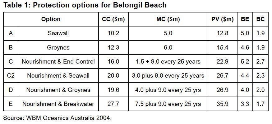 The salient point is that all options listed in Table 1 show net positive BE and BC ratios, with options A and C ranking the highest in respect of BE values. Options A and B entail both a physical and visual interference in their efforts to protect land at Belongil Beach, whilst others seek to limit intrusion and to retain as much of the beach as possible (C and C2). Despite these positive BE and BC ratios, all of these options were ignored by the BSC in favour of planned retreat.
In theory, planned retreat as a coastal management approach allows communities such as Belongil to enjoy the use of the coastal zone for an uncertain period until the projected sea-level rise causes significant erosion and inundation problems that landowners are forced to move on. In reality, though, its implementation could bring about a premature end to occupation of the coastal zone. As we documented earlier, present-day erosion is not driven by sea rise alone. On coastlines such as Byron Bay to Hastings Point, where wave-driven sand-transport episodes occur, the actual impact of sea-level rise on the coastline position is masked. We do not know for sure when the rate of sea-level rise will outpace natural variability in sand transport and, whilst this uncertainty remains, there seems to be no reason that medium-term solutions not be considered to manage the interim threat.
At present, beaches like Belongil are running out of time for any viable solution. It is clear that repeatedly spending resources on emergency-type works in response to storms is a waste of taxpayers’ funds. Encouraging landowners to pursue individual responses when it comes to protecting their own piece of the coast will lead to even more costly blunders and potentially irreversible damage to the coastal zone. It is also clear that he ‘do nothing’ approach of planned retreat has neither been costed nor well thought out. Medium-term approaches solve both of these issues, buying communities time in the face of an uncertain future.
The Final Alaysis
In Byron Bay the general public is at risk of losing its amenity in an iconic piece of coastline. Homeowners are at risk of losing homes, businesses their livelihood, and the government remains exposed to significant legal liability. It appears to be a lose–lose situation. A previous focus on long-term policies that failed to address more pressing immediate erosion issues has been replaced by short-term solutions. As part of its arsenal of methods for dealing with coastal management problems, the authors believe that NSW needs to consider engineering solutions for the medium term (~50 years) — or at least these should not be ignored a priori.
Given considerable infrastructural assets in coastal locations, it also seems improbable that large areas of the NSW coastline will or can be left undefended. It is not clear why homeowners are denied similar protection, especially given the uncertainty about when the rate of sea-level rise in a warming climate will outpace natural variability in sand transport at any particular point on the coast.
Landowners and policymakers need to arrive at a compromise where policy can adapt to deal with the present and medium-term problems, but also acknowledge that at some point, parts of the present coastline may well need to be abandoned as they become impractical and too expensive to protect.
This time has not yet come.
ACKNOWLEDGMENT: This article was cheerfully built on the work of Australian National University’s Kevin Roche, Ian Goodwin and John McAneney